:format(webp)/cdn.vox-cdn.com/uploads/chorus_image/image/65222693/worst_case_scenario_board_3.0.jpg)
This is part three in a three-part series about worst-case extreme weather scenarios in three regions of the United States — Arizona, California, and Florida — that are particularly vulnerable to the effects of climate change. In this story, we’ll consider why a Category 5 hurricane would be an especially catastrophic Big One for Tampa, Florida.
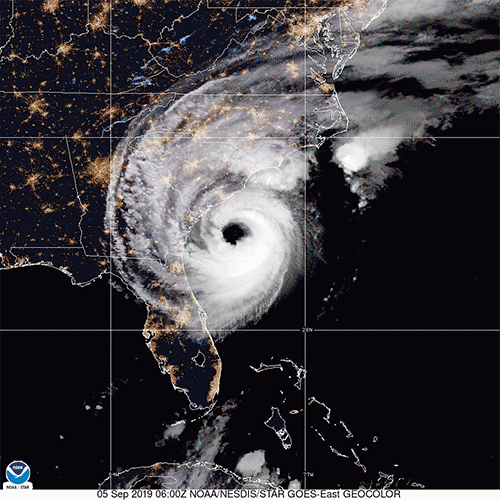
Tampa Bay is long and grows narrower and shallower as you move farther away from the Gulf of Mexico and toward the cities of St. Petersburg and Tampa, Florida. When a hurricane comes through Tampa Bay, its winds can push a wall of water, known as storm surge, into this ever-tightening container. So when a storm comes through, the bay rises.
Tampa Bay hasn’t been directly hit by a major hurricane with dangerous winds in excess of 111 mph since 1921. That hurricane pushed an 11-foot flood into the bay, killing eight, demolishing homes, and destroying an entire crop of citrus.
:format(webp):no_upscale()/cdn.vox-cdn.com/uploads/chorus_asset/file/19186535/1921_Tampa_hurricane_headline.png)
But back then, only 51,000 people lived in the city of Tampa and 14,000 lived in St. Petersburg. Now, the region is one of the fastest-growing metro areas in the country, home to more than 3 million people. Its economy has been thriving, home to a real estate industry, construction, financial services industry, and two major military bases.
It’s become a haunting question of when, not if, a big hurricane will return. Residents surrounding Tampa Bay have been spared the worst-case hurricane scenario many times before. Now, there’s so much more to lose. And sometime soon, we don’t know when, the worst-case scenario will arrive: a Category 5 hurricane, with winds in excess of 160 mph.
The Big Ones, Part One:
122 degrees for days: the looming Phoenix heat wave that could harm thousands
:format(webp):no_upscale()/cdn.vox-cdn.com/uploads/chorus_asset/file/19154590/heatwave_phoenix_board_3.jpg)
Here’s what it will look like: A monster hurricane — as big as they come — pushes an enormous amount of water into the bay. In downtown Tampa, at the north end of Tampa Bay, a Category 5 produces a 26-foot flood, more than twice the height of the 1921 storm. There, the downtown is built right along the waterfront, and the first floors of the buildings flood. In St. Petersburg, which is also built right up to the water, the surge reaches 20 feet, inundating much of downtown.
It’s predicted that when a Category 5 hurricane makes a direct hit on the bay, parts of Pinellas County — which is home to St. Petersburg — will temporarily become an island (see the chart below). The barrier islands on in the Gulf will be completely covered with water, connecting the Gulf with Tampa Bay through flooded parts of the county. People who chose to remain — or couldn’t evacuate — might be trapped. That’s because all the bridges that span Tampa Bay will be cut off, their entrances underwater.
:format(webp):no_upscale()/cdn.vox-cdn.com/uploads/chorus_asset/file/19190178/Hurricane_Phoenix_flood_fix_3.jpg)
Meanwhile, the 160 mph winds of the storm are blowing roofs off houses and smashing out the windows of high rises like a hole punch through a paper card. The winds destroy traffic control systems, like streetlights. In all, the storm destroys nearly half a million buildings in the area and 843,000 households are displaced.
We know what the power of a Category 5 storm can do: It’s always catastrophic. Hurricane Dorian, which lingered over the northwestern Bahamas for days as a Category 5 storm this summer, annihilated whole communities and created a humanitarian crisis that will take months and years to recover from.
Even in a well-developed, wealthy region like Tampa Bay, a Category 5 conjures a catastrophe. In the worst-case scenario, the storm could kill 2,000 people — a few hundred more than the number who died in Hurricane Katrina in New Orleans. And it’s likely the region would take years to recover. For one, there’s the rebuilding of the $250 billion in economic losses from the storm. And there’s also the emotional toll. After a major disaster, studies find a 5 percent to 15 percent increase in the incidence of mental health problems among survivors.
The scenario I just laid wasn’t made up by me. In 2009, the Tampa Bay Regional Planning Council drafted a plan for how to respond to a potential hurricane catastrophe, dubbing it “Hurricane Phoenix.” You might have read about it in a 2017 Washington Post feature on the region’s potential to flood.
The reason for this catastrophe plan: Tampa Bay is one of the areas in the US most at risk when hurricanes arrive because of its location, growing population, and the geography of the bay. This is the map of the storm planners fear the most.
:format(webp):no_upscale()/cdn.vox-cdn.com/uploads/chorus_asset/file/19188821/Hurricane_Phoenix_path_fix_1.jpg)
And as we creep into the future, climate change makes the chance of the above scenario happening more likely. As temperatures rise, it’s predicted that a larger proportion of storms will reach Category 4 and 5 strength. And even if these most-intense storms do not become more common, the storms of the future will still be worse due to sea-level rise.
:format(webp):no_upscale()/cdn.vox-cdn.com/uploads/chorus_asset/file/19186842/AP_19248533624708.jpg)
:format(webp):no_upscale()/cdn.vox-cdn.com/uploads/chorus_asset/file/19186844/GettyImages_1166596830.jpg)
How climate change is making hurricanes worse now and even more so in the future
First off, the science on how hurricanes will transform as the climate changes isn’t as clear cut as the science on how global warming will impact other extreme weather events, like heatwave risk or drought, James Kossin, an atmospheric research scientist at NOAA, says. “The heatwaves, the droughts, the effect of water availability, the effect of food availability and security ... all of these things are such existential threats, and we’re so confident in the human influence of these things,” he says.
The science on hurricanes, in contrast, is in need of more data. Scientists have only been tracking storms via satellite since the 1970s. It’s just hard to know if, today, these storms are becoming more frequent or more consistently powerful. In the future, however, they are predicted to.
Here’s what scientists are most confident in: The clearest consequence of climate change that will make hurricane impacts worse is sea-level rise. As the ocean warms and expands, and ice sheets in places like Greenland melt, seas are rising and more more water is available to inundate the land. Every inch more water can creep all that much higher during a storm surge.
:format(webp):no_upscale()/cdn.vox-cdn.com/uploads/chorus_asset/file/19154214/st_petersburg_chart_1.jpg)
In 2050, that 26-foot wall of water I mentioned above might be more than half a foot higher than it would be today. According to the US Army Corps of Engineers, the bay could rise a half foot (or more) by 2050. Even if storms don’t change at all in response to climate change, even if they don’t grow more intense, they’ll be more likely to cause damage due to the flooding.
But that’s if the storms themselves don’t change. In a hotter world, intense storms are predicted to grow a bit worse. The strongest prediction, with the greatest scientific backing, is that they’ll hold onto and squeeze out more moisture, in the form of rain, onto land.
“That is something we have very high confidence in,” Kossin says. “Everything we understand about the physics of the atmosphere and all of the models agree that we will see increased rainfall with these tropical cyclones in the future. We have a fundamental physical understanding that warmer air holds more water vapor.” The basic formula is that for every degree of warming Celsius, the air can hold 7 percent more moisture.
But “you can get increases of rain rates that are more than 7 percent,” Kossin says. That’s because as storms grow more intense, they spin faster. Air from the outside edges of the storm is drawn toward the eye, in a spiral, spinning faster and faster, like an ice skater drawing her arms in. That eye is like the spin cycle of a washing machine, wringing out more and more water the faster it turns.
There’s also some evidence that the forward pace of storms might be slowing down in a warming world. When a storm lingers over an area longer, it can dump more water on it. There’s also evidence that they may grow more intense, more quickly. The recent Category 5 Hurricane Dorian exhibited both of these traits: increasing its winds from 150 to 180 mph in just nine hours, and then lingering on Grand Bahama Island for 41 hours. It’s a nightmare scenario — intense sucker-punch hurricanes that linger — and it may grow more common in the future.
Thankfully, there’s an upper limit to how bad hurricanes can be. “There are laws of physics that limit how strong these storms can get,” Philip Klotzbach, an atmospheric scientist and walking encyclopedia of hurricane records at Colorado State University, says.
It’s not like in the future we’re going to see storms that reach 300 mile-per-hour winds. “In climate change, you warm the surface, but you also warm throughout the atmosphere,” he says. “If all you did was warm the surface and didn’t change the atmosphere, you’d see big changes, but given that you are also warming the atmosphere, that puts a brake on how much stronger the storms can get.”
So we’re unlikely to see storms with much faster wind speeds than what we see today. But any given storm is increasingly likely to be more intense, wetter, and slower than in the past. And in a warmer world, stronger storms may be able to creep farther and farther North, directing more and more powerful storms to the mid-Atlantic states.
:format(webp):no_upscale()/cdn.vox-cdn.com/uploads/chorus_asset/file/19187273/GettyImages_1165906998.jpg)
We need to, at least, prepare for the storms that have come before
A big reason why huge Category 5 storms will be worse in the future will be due to the fact that there will be more for hurricanes to destroy. Namely, we keep building and adding more people to hurricane-prone areas like Tampa Bay.
“The farther up the bay, the worse the hurricane storm surge potential,” says Bob Weisberg, an oceanographer who has studied the bay’s flood potential. “Curiously,” he adds, “the Tampa Bay regions with the most potential for damage are the ones that have been developed most rapidly over the past decade.”
Hillsborough County, which includes the city of Tampa, added 27,000 new residents in 2018. The weather forecasting company Accuweather has listed Tampa in their top five US cities most vulnerable to a hurricane. (Three of the five cities on that list are located in Florida.) It’s routinely listed on assessments of areas that have the most to lose during a powerful storm.
:format(webp):no_upscale()/cdn.vox-cdn.com/uploads/chorus_asset/file/19171550/ca_fire_lead_2.jpg)
These areas are at risk for a big storm. And yet, as Zac Taylor, a PhD urban planner who has researched climate risk for the Tampa region, explains, there’s a huge interwoven incentive system that continues to promote growth in the region. One overarching incentive is that Florida doesn’t have a state income tax. That means property taxes are continually needed to pay for services for Floridians. That motivates cities to keep building and accumulating property taxes.
Overall, Taylor says, these incentives lead to a situation where risk “isn’t adequately priced into [the costs of] development, and it’s not adequately controlled by land use planning.” So development thrives and attracts people to live there. This is not new: The great development of south Florida traces back to the end of World War II, Taylor says, with the proliferation of affordable mortgages for middle-class families.
And let’s not forget: The Tampa Bay area has boomed because people like living there. Development led to “families, churches, restaurants, and people living their lives, in multiple generations — children, parents, grandparents — and that ties people to places,” Jessica Weinkle, a catastrophic risk researcher at the University of North Carolina Wilmington, says.
:format(webp):no_upscale()/cdn.vox-cdn.com/uploads/chorus_asset/file/19187363/AP_19253475287516.jpg)
But residents need to reckon with the fact that a great cost of all this growth — in terms of the aftermath of a disaster — is being kicked into the future. Someone will have to pay when disaster strikes. And experts fear that cost will be divided unequally: Those who will lose the most in a Category 5 hurricane are the renters who don’t have their belongings insured, not the property owners who do. Those who will get injured or killed might be the people who don’t have the means to evacuate.
Though there is a great risk in the Tampa Bay region, the risk of destructive hurricanes exists for hundreds of millions more Americans living up and down the East and Gulf Coasts.
Given the history of the Atlantic Ocean, we know more catastrophic Atlantic hurricanes are coming. They’re coming for places like Tampa Bay; Charleston, South Carolina; and just about any place on the East and Gulf Coast.
Just look at what has come before. Here is a map of all the tropical storm and hurricane tracks in the Atlantic and Pacific near the US since record keeping began in the 1800s.
:format(webp):no_upscale()/cdn.vox-cdn.com/uploads/chorus_asset/file/19163544/Screen_Shot_2019_09_03_at_10.35.12_AM.png)
There is not a single state on the East Coast or along the Gulf of Mexico that has not seen a storm near its shore. There’s geological evidence that even New England has seen a Category 2-plus hurricane four times every century (at least for the past 2,000 years.) Any of those storms can repeat themselves, and when they come back, they’re more likely to be worse. The question that remains is how we will deal with them.
These storms are coming whether we are prepared for them or not. They will hit densely populated areas as well as rural stretches of coastline. They’ll likely be coming long after humans have vanished from the Earth. And from here on out, there’s a greater chance they’ll be more intense and drop more rain when they make landfall due to climate change.
“It’s just a matter of watching and waiting,” as Klotzbach says.
The problem is that many people living in these coastal areas still don’t know or accept how these areas are becoming riskier, not just from hurricane rains but also from sea-level rise and chronic flooding. “In general, we don’t prepare for what we’ve seen in the past, let alone what we might see in the future,” Klotzbach says.
Tampa may not be ready for the Big One
There’s no getting around it: The Hurricane Phoenix scenario mentioned above is a humanitarian crisis.
The strong winds will destroy or damage 1 million homes, the report found. Another 100,000 buildings would be destroyed or damaged by floods. Upward of 41 million pieces of debris — bricks, concrete, broken trees, etc. — would have to be cleaned up. Nearly 2 million people will be displaced from their homes. More than a dozen hospitals will be damaged and possibly unusable for nine months to a year. In all, the storm could cause $230 billion in damage.
And those numbers were based on Tampa as it existed in 2009. Today and in the future, those numbers would likely be larger.
Yet, as the 2017 Washington Post investigation revealed, the area has been slow to address sea-level rise and the many flooding risks that come from storms. Namely, development continues at a huge pace and few buildings are hurricane proof. Pinellas County “is growing so fast that there’s no land left to develop, and main roads and an interstate connecting it to Tampa get clogged with traffic even on a clear day,” the Post reported.
:format(webp):no_upscale()/cdn.vox-cdn.com/uploads/chorus_asset/file/19187425/AP_17252804393188.jpg)
Taylor says progress is being made in the Tampa Bay region in terms of moving the conversation forward on more sustainable planning. It’s not like this region is denying the realities of climate change. St Petersburg, for example, has pledged to be powered by 100 percent renewable energy by 2035. But more needs to be done.
The answers aren’t easy, or even all that desirable. Growth can be discouraged via state government action, making it more costly to insure property. Ideally, “We need to stop development of single-family houses in areas that are very vulnerable to flooding,” Taylor recommends. “We can make more, denser developments away from the coast.” Buildings can be built to stronger standards, evacuation plans can be honed, and the public can be educated about them. But perhaps, humans will also need to retreat, at least in some degree, from the most storm-prone areas.
The more the Tampa Bay area grows, the more people will be at risk for storms and sea-level rise. Again: We know that more storms are coming. They’ve come before. And they’ll keep coming, whether we’re here or not.