Colorado State University Atmospheric Science Professors David Randall and James Hurrell will collaborate with the National Center for Atmospheric Research (NCAR) to create a high-resolution version of an Earth system model used by scientists around the world. The National Science Foundation will fund the nearly $5 million, five-year “EarthWorks” project led by CSU.
The project will extensively modify a recent version of the Community Earth System Model (CESM), which is an open-source model used by many researchers to improve our understanding of the complex interplay of atmospheric, oceanic, land surface and sea ice processes that comprise the Earth system.
Though extremely useful and powerful for many science applications, such as investigating the impacts of a changing climate, the current model has limitations, including an inability to explicitly simulate thunderstorms and other relatively small-scale phenomena at its current low spatial resolution. Instead, storms, cloud formation and other similar processes are parameterized, or represented statistically.
While some Earth system models have sufficient resolution to simulate thunderstorms – called global storm-resolving models – none of them are freely available to the research community. EarthWorks aims to bring this global storm-resolving capability to their version of the community model, so all researchers can utilize it.
Modeling more realistic scenarios
“The fact that this is a community model that’s shared openly with everybody is unique and very valuable,” said Randall, EarthWorks’ principal investigator and a University Distinguished Professor. “Our intention is that everyone will be able to use what we’re building.”
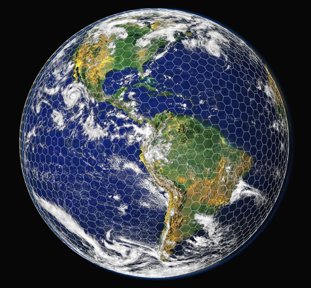
EarthWorks’ goal is to develop a version of the model that can run with a grid spacing of just a few kilometers. That’s a significant advancement, considering the Community Earth System Model typically is used with a 25- to 100-kilometer grid spacing. The finer resolution will be able to render important geographical features, such as individual large mountains, that play an important role in weather and climate. Coastlines, lakes and vegetation also will be better represented, and many complex chemical and physical processes will be simulated in a more natural way.
“It really opens the door to a much more realistic representation of what’s going on,” Randall said.
This level of detail is key to answering a lot of research questions, including many involving climate prediction.
For example, to fully explore how tropical cyclones might change with a changing climate, you need a model with high enough resolution to explicitly simulate the cyclones along with the full complexity of an Earth system model. You also need to be able to run the model for a long enough time period to detect how increasing greenhouse gases will affect cyclones in the future.
Atmospheric models for forecasting weather run at a resolution high enough to accurately capture the formation and evolution of individual cyclones, but they typically aren’t used with a complete representation of atmospheric, oceanic and surface processes, and they are run for short periods of time.
“We want to run at weather-forecasting resolutions but for years to decades into the future,” said Hurrell, a co-principal investigator and the Scott Presidential Chair in Environmental Science and Engineering. “That will allow us to study a class of problems at the weather-climate interface that can’t be addressed with coarser resolution.”
Computing advances help project
EarthWorks will combine particular versions of the atmospheric, oceanic, land surface and sea ice models that will enable the overall model to run efficiently at high resolution on today’s computing systems. All of the component models will run on a single enormous grid, with its points spaced 3 to 4 kilometers apart, covering the entire planet. That amounts to tens of millions of points, requiring a lot of computing power.
Recent computing advances – including the use of graphical processing units, or GPUs, for scientific applications – will make the project possible, along with experts in the field. GPUs, originally used to render 3D video games, can help speed up Earth system models by solving equations for many different grid points simultaneously, but they require the traditional model code to be re-worked.
“We’re excited to partner with CSU on realizing high-resolution Earth system model experiments using GPUs,” said NCAR’s Rich Loft, a co-principal investigator on the project who will be leading the code redevelopment. “The role of our team will be refactoring and optimizing key model components for GPUs and integrating them back into the model source. We will also experiment with introducing machine-learning components into the model, along with other upgrades meant to make the model as computationally efficient as possible.”
Randall and Hurrell will work with two other NCAR co-PIs, Andrew Gettelman and William Skamarock, to develop the EarthWorks Earth system model. NCAR supports the Community Earth System Model, and the co-PIs will make sure EarthWorks remains compatible with the community model. The ultimate goal is for the EarthWorks version of the model to be adopted back into the community model framework by CESM management.
“Our objective is to fill a void in the spectrum of Earth system modeling in the U.S., and then deliver that back to the CESM community and hopefully have it enthusiastically adopted,” Hurrell said.
The Community Earth System Model is critical infrastructure for the U.S. climate research community. The NSF Cyberinfrastructure for Sustained Scientific Innovation program is funding this project to create new infrastructure to satisfy an emerging need.
“This is where the field is moving now, and we need to be there,” Randall said. “Otherwise the field will move on without us.”