Along active faults like the San Andreas Fault in California, monitoring stations detect where subtle lateral movements happen – or don’t. If most of the fault keeps shifting, but one area remains still, it can be a sign that pressure is building there. That growing pressure will eventually be released in an earthquake, and scientists refer to it as “seismic risk.”
Subsidence is a different, mostly vertical type of land movement, in which areas sink as subterranean support weakens due to groundwater pumping, oil and gas exploration, or other changes.
A new half-million dollar grant from NASA’s Earth Surface and Interior Program will enable Department of Civil and Environmental Engineering Assistant Professor Ryan Smith to advance our understanding of seismic risk, subsidence, and the ways they interact.
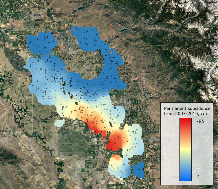
In California’s heavily agricultural Central Valley, groundwater use has contributed to up to a foot per year of subsidence in recent decades. The heavily-monitored San Andreas Fault runs right through the valley, too. Subsidence interferes with accurate estimates of fault movements, and vice versa. That’s where Smith’s research comes in.
Smith’s group will work to improve understanding of both subsidence and fault movement, improving the models scientists use to study seismic activity. Their primary tool will be satellite radar interferometry instruments capable of measuring ground elevation from orbit with sub-centimeter accuracy. Recent advances in computational methods have unleashed the power of this sensitive radar instrument, allowing scientists to produce thousands of “interferograms” – maps showing the elevation changes between two satellite passes – in less time than it previously took to produce one.
Back on Earth, groundwater level monitoring from wells, continuous GPS stations that detect movement along faults, and data from oil and gas extraction will help Smith’s team create an extremely thorough picture of the processes being studied.
“Folks who are working on seismic risk tend to ignore the groundwater side, but we’re showing that subsidence is a crucial component to include in some of these models,” he said.
The work Smith and his colleagues will be doing under this NASA grant also has the potential to increase our understanding of subsidence in its own right.
“I hope that we’re able to use this to improve the way that we model subsidence and our groundwater resources. That could help us with improved groundwater management.”
Refinements in scientific models of subsidence could pay off in locations far from California’s Central Valley, too. Subsidence is a major concern in communities from Mexico City to Indonesia and China.
“In eastern coastal China, sea level is rising at maybe half a centimeter per year, and then the land is sinking 10 centimeters per year,” Smith said, “so in some areas subsidence is even a much bigger issue, locally, than global sea level rise.”