DENVER — Colorado State University (CSU) has released its Forecast for 2021 Hurricane Activity.
Based on satellite data and ocean temperatures, researchers are predicting an above-average year with 17 named storms, eight hurricanes and four major hurricanes.
“Its not a huge leap here. We're not coming out and calling for last season to repeat itself, but what we are saying is the signals are there that this could be an active season, and it never hurts to have your guard up, maybe, a little higher," said Alex DesRosiers, a CSU research assistant.
According to Chief Meteorologist Mike Nelson, one of the key ingredients for tropical storm activity and hurricanes is the sea surface temperatures this time of year — they're still quite cool down across the Gulf of Mexico and out where the Gulf Stream is off the coast of the United States.
But that very warm water is one of the key things the CSU researchers look at to forecast how much activity we'll have. It looks like there will be a lot of warm water out there as hurricane season begins.
Another thing is the tropical cyclone energy, which is a combination of the heat and the moisture that has to do with storms that actually form in Africa and how much moisture you get there. At lower latitudes, the primary driving winds are not from west to east, but actually go from east to west. That's why we watch the coast of Africa for storm development when we get into hurricane season. So, that is also adding in to this play for a more active season.
If you have a lot more dust that blows off the Sahara, that actually can cause a cooling, which means fewer storms.
We also have to look not only at the Atlantic Ocean, but the Pacific Ocean plays a role, where El Niño and La Niña conditions occur.
El Niño conditions are when we have warmer water in the Pacific, which adds a lot of thunderstorms and energy into the atmosphere, not only in the Pacific, but it also changes the way the jet stream flows. Very often when we have an El Niño year, warmer water in the Pacific increases the vertical wind shear all the way into the Atlantic, and that decreases tropical activity.
We're coming off more of a La Niña condition and that is less vertical wind shear and tends to increase that tropical activity.
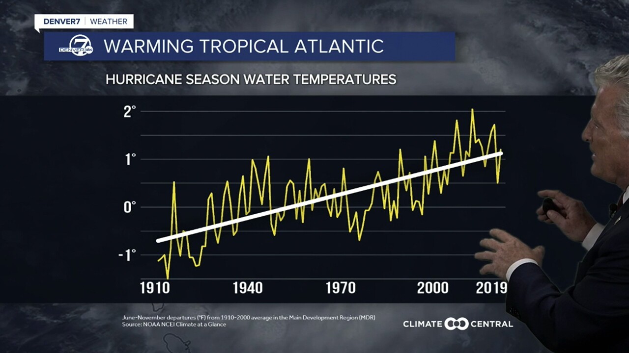
As we get a warmer world with global warming, we are seeing the Atlantic hurricane season water temperatures increasing. Warmer water means more energy. With that, we're seeing more storms coming as major storms.
We certainly saw that last year and, unfortunately, at least according to Colorado State University forecast, we may be seeing that again coming up this hurricane season.
The forecast release also begs the question, why are researchers high in the Rockies focused on hurricanes?
The late Dr. Bill Gray at CSU's Department of Atmospheric Science really started doing these studies back in the mid-1980s. Some of the top tropical meteorology scientists in the world do their forecasting at CSU.
Gray previously said being a mile above sea level, you don't have to worry about the storm surge.


