Lindsey, who said he has been anxiously counting down the days until the launch, called GOES-U a “sentinel in the sky” because of the satellite’s ability to provide continuous observations of the weather over the United States. One of the primary missions it supports is tracking hurricanes so that high-risk coastal states get extreme weather warnings in a timely fashion.
NOAA’s Geostationary Operational Environmental Satellite program has provided Western Hemisphere imagery continuously since 1975. Geostationary satellites, positioned at an altitude of 22,300 miles, fly in orbits that match the Earth’s rotation and appear to stay in a fixed location in the sky from the perspective of an observer on Earth. GOES-U includes many improvements compared to the preceding three satellites launched in the GOES-R series. GOES-U will have a new compact instrument to support monitoring space weather, called a “coronagraph,” such as the recent widespread northern lights in mid-May.
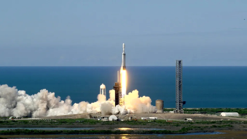
GOES-U launched on a Falcon Heavy launch vehicle, manufactured by SpaceX. The Falcon Heavy has a particularly high payload capacity. GOES-U itself is about the size of a school bus and weighs about 11,000 pounds with fuel.
After several weeks of boosting maneuvers, GOES-U will reach a checkout geostationary orbit and be renamed to GOES-19. Once instrument checkout and first-light observations from its instruments are completed, GOES-U will be moved to 75 W longitude and replace GOES-16 as GOES East, likely in April 2025.
Next, CIRA researchers are looking forward to the GeoXO (Geostationary Extended Observations) satellite program, which will replace the GOES-R series spacecraft in monitoring the Western hemisphere. NOAA anticipates the new system will be deployed in the early 2030s. The new system will have improved visible/infrared imagery and lightning mapping capabilities, as well as hyperspectral sounding, atmospheric composition, and ocean color observations.
Improved data and visuals from GeoXO will support scientists researching the Earth and its environment. High-quality satellite images also make visuals more accessible for operational forecasters in the National Weather Service and for other users, including the public.
One example of such imagery is the GeoColor product, developed at CIRA, that makes ‘true’-color imagery possible.
“GeoColor provides a natural entry point for understanding the power of GOES—conveying the complexity and beauty of our planet’s weather in a simple, intuitive way that everyone can appreciate,” said Steve Miller, a professor of Atmospheric Science at CSU and director of CIRA. True-color imagery helps weather reporters to clearly get across the information that they are sharing. Visuals that come from these systems are common on major media outlets when there is an event like a tropical storm or volcanic eruption.
GeoXO will also improve the detection, monitoring, and characterization of environmental hazards like wildfires, dust, volcanic ash, drought, severe weather, hurricanes, winter storms, and the rivers of moisture that cause widespread flooding. Providing advanced warning of environmental hazards to policy- and decision-makers can improve risk management and public safety, including coastal evacuations in advance of hurricane landfalls.
These satellite programs collect information that CSU researchers use to develop and run sophisticated numerical forecasting models predicting emerging weather and climate patterns. To support NOAA’s long-term planning for the effects of climate change, scientists at CIRA will continue working behind the scenes to provide climate information and services for national benefit.
“CIRA has enjoyed a close partnership with NOAA since 1980, traversing many generations of satellites together,” said Miller, “We look forward to working with GOES-U and the future GeoXO to help society keep one step ahead of the ever-changing weather.”