The emergence of stronger and rainier thunderstorms that are able to quickly spawn tornadoes is posing problems for meteorologists.
Storm experts assembled here last week for a gathering of journalists at the National Center for Atmospheric Research (NCAR) described these storms as intensifying, but too small to be forecast by computer models. They often develop too quickly to give more than an hour of warning. Even then, forecasters can sometimes give only a blurry picture of where the storms will hit.
Russ Schumacher, the state climatologist of Colorado and an associate professor at Colorado State University, described a tornado that hit the suburbs of Oklahoma City on the evening of May 31, 2013, as an example.
On supporting science journalism
If you're enjoying this article, consider supporting our award-winning journalism by subscribing. By purchasing a subscription you are helping to ensure the future of impactful stories about the discoveries and ideas shaping our world today.
The fast-approaching storm drove some people out of their apartment buildings to seek shelter from the wind in a nearby underground cement drainage tunnel. It soon flooded from heavy rains, and five people drowned, including four children brought there by their parents to seek safety.
Meanwhile, at least one television station advised people in Oklahoma City to get in their cars and race out of the path of the storm, leaving motorists sitting on freeways already packed with rush-hour traffic. Fortunately, the storm, called the El Reno tornado, leaped over most freeways and avoided the densely populated areas of the city.
The storm carried winds of over 295 mph—the second-highest ever recorded. It sent some cars airborne, killing four hurricane chasers who were tracking it for local media. One meteorologist estimated afterward that if the storm had hit the jammed freeways, the death toll could have exceeded 500.
Another remarked: “You lay that path over Oklahoma City and you have devastation of biblical proportions.”
The problem in these situations is you can have “two different actions you’re being told to take at the same time,” said Schumacher.
“This is still a major issue,” he added, explaining that contradictory advice about how to survive a storm now emerges in 350 incidents per year in the United States. It usually happens in the Lower Mississippi Valley and along the Gulf Coast.
“This is a challenge we have as forecasters,” Schumacher said. “We still have these problems about how to inform people.”
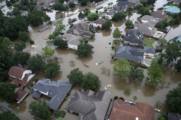
During Hurricane Harvey, people in the Houston area were given a series of warnings that alternately warned them to seek shelter underground to avoid dangerous winds or to find high ground to avoid flooding. Both perils were happening simultaneously.
The problems start with the nature of recent thunderstorms, explained Morris Weisman, a senior NCAR scientist. They arrive with “very intense vertical motion” consisting of updrafts from the warmer earth into the sky and downdrafts coming from cooler, but more moisture-laden air down to the ground.
They can create internal winds that reach more than 150 mph.
The thunderstorms can cluster, creating new storms as they do, then move out in different directions or head out in a straight line. The latter kind is called a derecho, and it can give repeated poundings to areas in its way.
Computer models, which view geographic regions in grids, can depict big storms like Harvey, but so far they can’t see an area that’s 0.62 mile or smaller. That’s the resolution needed to show how these thunderstorms work, said Weisman.
Meteorologists can use a variety of models to estimate where these storms are headed, then average them all to determine the most likely path. “You get a probabilistic sense of where the main damage will be occurring,” Weisman said.
Julie Demuth, another NCAR meteorologist, said scientists have begun to to study tweets by people caught in these storms. She remembers seeing a social media message from a couple in a Georgia trailer court as a tornado approached. Would they run for it or put their small children in a windowless closet in their home? The wife was arguing “there’s nowhere that’s safe.”
Antonio Busalacchi, president of the University Corporation for Atmospheric Research, which runs NCAR, said one way to make better predictions is to increase computer modeling power. That effort is underway in the United States, but at the moment, European weather agencies have “better access to more high-performance computing than we do, more advanced data simulation capabilities.”
They’re able to attract experts “by paying very high wages. They get the best of the best,” he explained, noting that U.S. agencies are working with the Europeans to improve their modeling capabilities.
Meanwhile, Busalacchi and other experts noted that a rising number of private U.S. firms have emerged. Some are studying the uses of small, steerable satellites, called “cubesats.” They’re studying new ways to track storms, with the hope of selling the information to government agencies in the United States and China.
Historically, the United States has shared what it knows about storms with just about anyone. But access to that information might be changing. What if a private vendor acquires lifesaving information? Will it be distributed widely, even to people who don’t pay for it?
“There is no master plan as to how we’re going to do it,” explained Scott Rayder, a senior adviser to Busalacchi.
Reprinted from Climatewire with permission from E&E News. E&E provides daily coverage of essential energy and environmental news at www.eenews.net.