NSF has awarded CSU Assistant Professor Ryan G. Smith a $328,981 grant to study how subsidence, or the sinking of land area from the removal of groundwater, affects long-term water availability in southwest Utah.
Using data from satellite imaging, Smith, in the Department of Civil and Environmental Engineering, will investigate how the unmonitored pumping of groundwater is affecting the storage capacity of confined aquifers.
Peering underground from space
Smith uses satellite technology known as Interferometric Synthetic Aperture Radar (InSAR) to retrieve data on confined aquifers. These aquifers are typically much deeper underground and harder to study than shallow aquifers, which are often connected to rivers and other bodies of water and are more easily accessible by drilling wells. This technology, which can detect millimeters of movement in the ground surface, allows researchers to obtain extensive data on confined aquifers over large regions rather than drilling an expensive well that will only provide data on that single location.
When groundwater is pumped to the surface, it is pulled from the rock and sediment in aquifers holding the water, including clay. Clay will compact when water is removed, prompting the gradual sinking of the surface above. The storage lost from clays can comprise a large portion of the total storage in confined aquifers, and can be seen from space with this radar.
The goal of Smith’s study is to formalize methods of using radar and other satellite technology to measure and monitor the amount of groundwater storage lost in these confined aquifers.
Arid land and cold calls
Smith was drawn to study this specific region in Utah due to the picture-perfect satellite images of confined aquifers combined with a lack of prior research performed in the area.
“This is a perfect example of the capabilities of this satellite technology to monitor changes in groundwater storage,” Smith said.
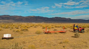
In November 2021, Smith collected data from the Parowan area of southwest Utah using a towed time-domain electromagnetic system to scan the aquifer, much like an MRI images the body. The resulting images reveal the locations and thicknesses of sands and clays from the surface down to 200 feet below ground. These images will be used to better understand why subsidence occurs in certain parts of the region, and to understand how and where water from the surrounding mountains recharges groundwater in the valley.
This specific region in southwest Utah supports a small rural community in which the primary livelihood is agriculture.
“They need to know how much water they can be pumping sustainably,” Smith said.
Although the community is going through a groundwater management plan with the state’s Division of Water Rights, there is still a significant amount of uncertainty about the amount of groundwater being used and the water supply remaining.
This study will be a collaboration between Smith and a stream flow researcher from Southern Utah University, Assistant Professor Erich Mueller. Smith cold-called Mueller about the research idea and Mueller agreed to contribute his expertise.
Smith also reached out to the Utah Geological Survey, the Enterprise Iron Conservation District, and the Parowan Pumpers Association. These organizations connected him with farmers in the region who proved invaluable to Smith’s research by sharing their challenges and granting access to their land and wells for data collection.
Smith recognizes collaborating with the agencies that will directly use this research allows it to have a greater impact and advance the science.
Why water?
Smith’s interest in groundwater sparked from his time living in Iceland, surrounded by the innovative use of geothermal energy. He knew groundwater would be the foundation of his future research and changed his undergraduate major at Brigham Young University from mechanical engineering to geology. While he appreciated the study of the subsurface, he sought a more concrete, quantitative approach to data, eventually earning a PhD in geophysics from Stanford.
“A lot of people need groundwater for drinking or for irrigating their crops, but we still have some big question marks about how much there is to pump, and how much we’ll have down the road with climate change,” explained Smith.
Ultimately, Smith wants to make a difference with his research: “This is an issue of the future – an environmental issue which could have a direct and immediate impact.”