A new National Geographic series features satellite data that Colorado State University researchers turn into images – information that routinely helps weather forecasters and meteorologists around the globe.
In this new six-episode film series executive produced by National Geographic, viewers will get an unprecedented view from the inside, traveling with scientists on hurricane-hunting aircraft, oceanographic research vessels, and in the forecast rooms where life-and-death decisions are often made.
Many of the images shown in the series have been provided courtesy of CSU’s Cooperative Institute for Research in the Atmosphere or CIRA, which is a partnership between CSU and the National Oceanic and Atmospheric Administration, known as NOAA.
Tropical storms remain one of the most challenging of all forces of nature to understand despite significant advances in the ability to forecast and observe their features.,. Every year, scientists across the country, from a broad background of expertise and talent, gather during the tropical storm season to begin the exciting process of forecasting these storms.
Turning raw data into images
At CIRA, researchers are engaged with the process of taking raw satellite imagery and using the science of how light interacts with the atmosphere to develop new imagery products, ones which give forecasters the upper hand in understanding tropical storms.
“Satellites are an invaluable tool for monitoring the weather on both a global and local scale. The images they provide allow for a rapid assessment of the intensity of developing storms,” said researcher Curtis Seaman, one of the scientists involved in creating several of the products used in the National Geographic series.
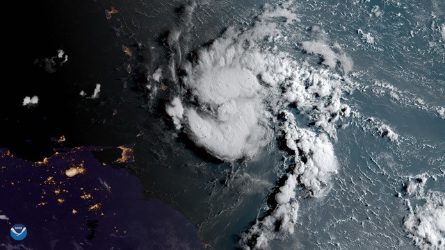
Among the products developed by CIRA featured in the series, one called the ‘GeoColor’ product is used extensively by media and researchers. By cleverly combining imagery from the visible and infrared spectrum from a range of satellites, CIRA scientists can create a 24/7 picture of the Earth as a human observer in space would see it – even at night, which is particularly useful for tropical storm researchers looking to pin down a developing storm’s exact location.
CIRA also developed a product using a special instrument on the GOES series of satellites that produces images of lightning strikes, a valuable observation that relates to the strength of growing cells within a storm. By combining the GeoColor and lightning data, researchers can create a comprehensive and intuitive picture of what’s happening in the tropics.
Telling a story to inform
“Combining two layers of imagery can motivate new research questions and provide incredibly stunning visuals,” said CIRA researcher Dakota Smith. “These satellite perspectives illuminate that tropical systems can behave in vastly different ways, driving scientists to learn more about these differences.”
An agreement between CSU and Keo Films, the producers of the National Geographic series, provided a wide range of CIRA imagery to the filmmakers, including Hurricanes Dorian and Humberto and other imagery that helps tell the story of how scientists study these compelling storms. (Watch a CIRA loop of Hurricane Dorian).
“The more people that see satellite imagery of hurricanes the more informed we are as a society on how they form and the risks they bring,” said Smith said.
Founded in 1980, the Cooperative Institute for Research in the Atmosphere is one of sixteen cooperative institutes between the National Oceanographic and Atmospheric Administration (NOAA) and universities engaged in NOAA-relevant research. As part of the Walter Scott Jr. College of Engineering at CSU, CIRA works with NOAA, NASA, and other agencies to develop research-based products for operational use in forecasting and research.