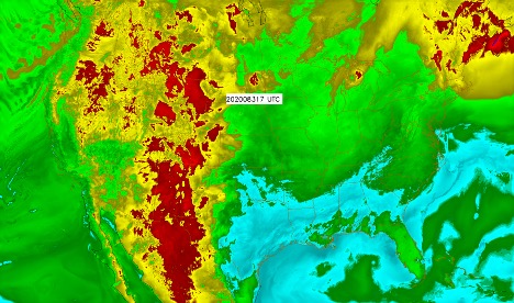
Map of viral reproduction rate for Monday, March 23, at approximately 11 a.m. MDT, generated at CIRA. Experimental only – not for decision making.
As scientists and medical staff gear up to fight the virus causing COVID-19 globally, little is known about the impacts of environmental variables like temperature and relative humidity on how the virus spreads. Researchers at the Cooperative Institute for Research in the Atmosphere (CIRA) at Colorado State University are hot on the trail in developing tools to find out if the virus responds to seasonal- and weather-related factors, including a tool that could soon potentially be used to predict and understand how the virus is spreading.
Although still very much a work in progress, scientists have started looking at the spread of the virus throughout China, Singapore, and other countries. With careful analysis, these scientists can look at how fast the virus spreads using data from hospitals, and then compare that data to environmental factors, including temperature and relative humidity. Preliminary results suggest that these variables might have an impact; it’s known that the influenza virus typically spreads faster in colder, drier climates, and there’s some work that suggests that the novel coronavirus might respond similarly.
If scientists can link the growth and spread of the virus to temperature and humidity, the next step is to take the relationship discovered and map that to current weather conditions. John Forsythe, a researcher at CIRA, is looking at and mapping these preliminary correlation analyses using data from NOAA’s High Resolution Rapid Refresh forecast model.
“CIRA routinely ingests real-time weather and satellite data and forecasts from all over the world,” he said. “If weather conditions such as temperature and moisture can predict less dangerous times for transmission, this could be useful to decision makers.”
Weather forecast models
Using temperature and relative humidity data from the model, Forsythe can compute parameters like the basic reproduction number for the virus, which represents the number of expected cases generated through contact with one infected person. A higher number means more individuals are expected to become infected – and if temperature and humidity impacts that number, then forecasting the spread of the virus can follow weather forecast models.
These “weather” maps of virus parameters could be used by epidemiologists to study and manage community responses to the spread of the virus. Studying weather patterns in terms of virus dispersal or the likelihood of getting sick in the first place is also an option.
“If weather impacts the length of time viral particles are suspended in the air, then the potential for exposure would be increased,” said Professor Lorann Stallones, a professor in the Department of Psychology who specializes in epidemiology and applied social and health psychology. “Alternatively, if weather impacts our respiratory systems in a manner that impacts our ability to clear viruses before becoming ill, then there is a higher probability of becoming ill if exposed by increasing susceptibility.”
As the global pandemic continues, CSU researchers on all fronts are dedicated to studying the virus, including anything that can be used to slow its spread. If weather and seasonality are tools that can be used in this fight, then CSU has exactly the right toolbox to get to work on helping fight COVID-19.
The Cooperative Institute for Research in the Atmosphere at Colorado State University is one of sixteen Cooperative Institutes nationwide, partnering universities and the National Oceanic and Atmospheric Administration and providing academic and research expertise to improve the operational forecasting performed by NOAA. CIRA has expertise in climate and weather processes, satellite observations, numerical weather prediction, data assimilation, data distribution, and other fields.
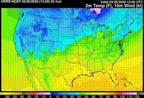
Temperature and wind forecast from the High Resolution Rapid Refresh (HRRR) model, which can be used to generate experimental maps of virus reproduction rates for forecasting the spread of the virus that causes COVID-19 (credit: NOAA/ESRL/EMB)